Publication of the full trail awaits my completion of a final couple of tracks, so that I can confidently say I've covered the whole lot, had time to enjoy myself and take photos, and I'm still here to write about it. The Waitakeres being as they are it will likely be November before things dry out enough. Catch you later. |
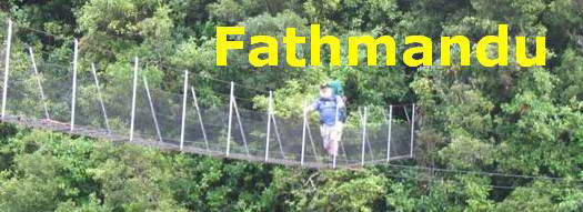
Designing the Fathmandu Trail was a challenge I put to myself after a week or so grizzling and grumping about the Hillary Trail and it's utter disregard of the needs of the elderly and/or stout.
As it is at present laid out, the Hillary Trail is not a viable option for the elderly and stout in the same way that, for example, the Heaphy or the St James Walkway, or even the Milford, can be seen as realistic multi-day tramping goals for a wide range of people.
 One of the features of our Great Walks in New Zealand, (with the notable exception of Day One of the Waikaremoana Walk) is that they provide a safe and manageable corridor for a wide range of age groups through some challenging and dramatic countryside. Looking outwards from the tracks you can place yourself in the shoes of our earliest explorers. On the tracks you're safer than you are on a trip to the corner dairy. And at the end of the day, there's a hut and a mattress and a drinkable water supply.
Who in hell would want to walk day 4 on the Hillary Trail: 27km on a muggy Auckland summer day traipsing up the coastline with no shelter and no drinkable water en route, exposed to the sun, and with the major point of interest the horizon between here and Australia. Even chopping the last day in two with an extra campground scarcely does a lot to attract anybody outside the fit 18-35 year old bracket. Imagine taking a couple of kids on it, or your parents...
And there's so much to do and see in the Waitaks besides paying close attention to where your next foot will be placed, so as not to fall off something. (Hillary Trail booklet advice on negotiating Muir Track, at the end of another long day.) I have been so much looking forward to the idea that a multiday tramping experience was going to be available in the Waitaks that my disappointment with the Hillary Trail as it has emerged is profound.
Really, what would it cost to put a half dozen standard DOC huts in the Waitaks, for long term benefit for all age groups, as well as a multitude of tourists, considering the money we're proposing for a downtown party centre for the Rugby World cup, all over in a month or so?
Enter the concept of the Fathmandu Trail.
You're in Auckland, and you'd like to spend a day or several days tramping. Instead of a tent and sleeping gear and four days' clothes and food, we'll take a daypack with a decent lunch, and the normal emergency gear we'd have with us anyway. We'll sleep in our own beds at night, or in a handy motel or backpackers if we're from out of town, with showers and a decent evening meal and a bottle of wine.
What we will need for most walks is somebody to drop us off and pick us up at pre-arranged times, or two cars that we can arrange to leave at either end of the day's walk. The Waitaks are not, on the whole, geared for loop walking, though you can do quite a bit out of Cascade Kauri Park, or Glenesk Rd at Piha. And through most of the Waitaks cellphone coverage is zero.
The Fathmandu Trail is a series of day walks over tracks that I have personally traversed in the last year or three. You can have a wander round my site for a photo record of most of these trips. There are no signs on the ground that you can follow: the trail is a concept, set out on this website. It will pay to visit the Arataki Visitors Centre and purchase an ARC map of the Waitakeres which sets out clearly all of the available tramping tracks, and is a good deal more up-to-date tham the Topographic series.
With a couple of exceptions, each day walk described is about 10-12 km in length, and around 5-7 hours of fairly comfortable walking. While some of them take you through steepish territory, all tracks are securely fenced where there's a dropoff: you won't fall off them.
Warning:
This is not an invitation to get up from your tv or your computer and launch in to one of these walks. You wouldn't attempt the Heaphy or the Milford without training and you shouldn't be setting out on an 8-12km hike in the Waitakeres without some previous training, especially once you are past 50.
And do see your doctor before you begin any major training regime.
That said, the rewards are out there for you. |
At this stage, all you'll get is a track map. Later, as I revisit all these old friends, I'll update the photo record accordingly.
Each map square corresponds to 1 square kilometre. Where the photo record has been updated the day heading has been turned into a link.
Day 1 Cascade Kauri to Mountain Rd, Henderson

Day 2 Fairy Falls to Piha
2a: Fairy Falls Circuit

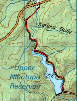
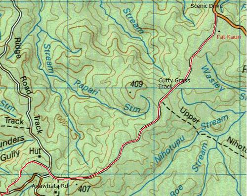
2b Cutty Grass Track
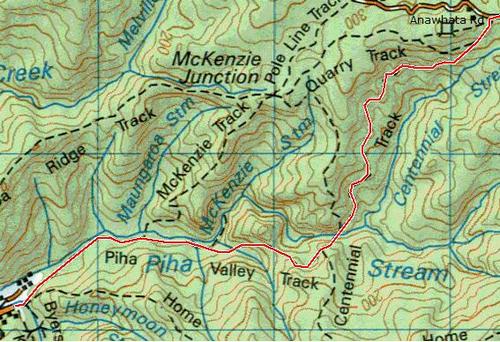
2c Anawhata Rd to Piha
Day 3 Piha to Huia - One Dam Thing After Another